MISTRAL
Geography & Meteorology
No one understands energy better than Mistral!
Mistral standard program feature that with a single mouse click:-
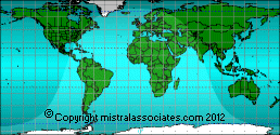
Automatically loads all diurnal meteorological data from user editable geographical national databases covering all countries or regions of the world, along with insolation factors, solar azimuth and declination angles (thus compound incidence angles), for any structure at any orientation at any location clicked on any one of 60,105 zoomable, detailed and seamlessly scrolling interactive world maps (to a location sensitivity of plus or minus 500 metres when zoomed to maximum resolution).
Thus computing total conductivity gains or losses, plus primary and secondary radiation and reflectance incident values through any number of structure surfaces, arranged at any plan angle, made up of any compound mixture of building and insulation materials, plus fenestration. With correction for surface air boundary layer effect (still air and moving), adjacent ground surface reflectance, surface colours and shading. At 15 minute intervals for the entire year.
Instantly switchable between SI (metric) and Imperial units (repeated switching without incurring cumulative 'rounding errors').
Mistral's imitators - Dont!
Loads solar azimuth, declination, sun hour strength factor and climatic data at 15 minute intervals for year at selected position.