
Selecting a location in the geography  part of the program, simply with a single Mouse click on a zoomable, interactive
world map, automatically retrieves then enters the complete annual meteorological profile for the selected location. This is stored in a vast world meteorological database
included with the program. The database may be edited and added to by program users through a logical and easy to use 'menu driven' interface also supplied.
part of the program, simply with a single Mouse click on a zoomable, interactive
world map, automatically retrieves then enters the complete annual meteorological profile for the selected location. This is stored in a vast world meteorological database
included with the program. The database may be edited and added to by program users through a logical and easy to use 'menu driven' interface also supplied.
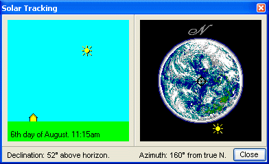
Supplimenting the meteorological data the program employs sophisticated solar azimuth and declination (sun angle relative to true north, combined with sun height above horizon) routines to calculate solar radiation gains. Both direct gains and secondary gains through reflection from adjacent surfaces.
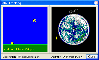
The progress of the program in applying this data is simply demonstrated in these (sample) novel 'thumbnail' and 'live' graphical images.
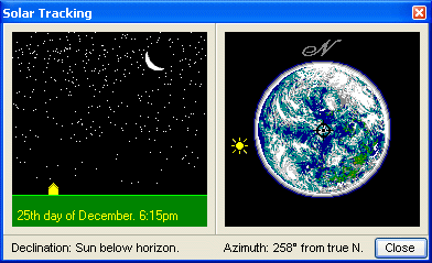
Select any world city and choose any time of day, for any day of the month, across the entire year, and the program will almost instantly re-compute the precise energy gain or loss for the structure design entered into the program. A process involving up to 175,000 seperate mathematical calculations per second!